2012年7月6日

ArcPad.GPS POSITION WINDOW GPS 定位視窗

點選[GPS定位視窗]

GPS定位視窗顯示衛星、位置坐標及導航資訊有關的資訊,分為數據,衛星分佈,質素及調試4個分頁。
[數據]分頁

GPS坐標有以下不同坐標表示方式:
  • Map Projection (地圖投影座標系統)
  • DMS (dddºmm'ss.sss")
  • DMM (dddºmm.mmmm')
  • DD (dd.dddddddddº)
  • UTM (橫麥卡托投影座標系統)
  • WGS84 DMS (dddºmm'ss.sss")
  • WGS84 DMM (dddºmm.mmmm')
  • WGS84 DD (dd.dddddddddº)
  • MGRS (軍用方格座標)


GPS模式
  • NOFIX: 沒有位置
  • 2D: x,y 位置
  • 3D: x,y,z 位置
  • DGPS 2D/3D:差分定位
  • SBAS 2D/3D: 星基增強系統定位
  • RTK fix/flt: 即時動態定位(固定或浮動解)
  • PPS 2D/3D: 精確定位服務


Altitude高程
  • 高度(米或英尺)
  • 深度 (米或英尺)


[衛星分佈]分頁,顯示目前高空中的衛星位置,柱狀圖高低表示訊號強度,灰色表示訊號太低未採用。

[指南針]分頁,TCOG表示 真北航向。

[質素]分頁,顯示目前的GPS訊號精度

[調試]分頁,顯示目前接收到的GPS訊號

Reference to ESRI® ArcPad® 10 Quick Reference

2012年7月4日

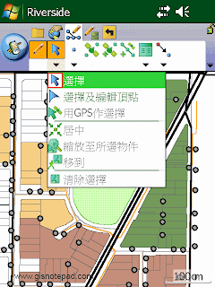
ArcPad.ET.SELECT 選擇下拉清單


Select 選擇
Activate the Select tool. 啓動選擇工具
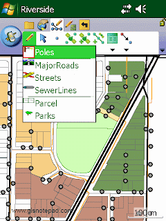
ArcPad 10-Select
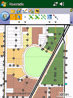
Step1 要啟動[選擇]功能,必須先將圖層設定為編輯狀態。我們以[Poles]圖層為例,先點選[Poles],使其成為編輯狀態(紅框)。

Step2 點選[選擇]

Step3 點選地圖右下角的1支電桿,被選取物件,會反藍顯示,表示選取中

Select And Vertex Editing 選擇及編輯頂點
Activate the Select And Vertex Editing tool. 啟動已選物件的頂點顯示及編輯

Select At GPS Position 用GPS作選擇
Select the feature at the current GPS position.在當前的GPS位置作選擇物件

Center On Selected Feature 居中所選物件
Center the map on the selected feature without changing the current map scale. 所選物件移動到視窗中央 但不改變現有地圖比例
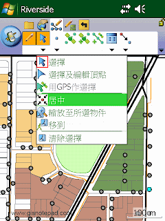
Arcpad 10-Center On Selected Feature
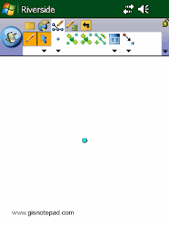
Step1 點選[居中]

Step2 原本右下角選取(反藍)的物件,移動到視窗中央

Zoom To Selected Feature 縮放至所選物件
Zoom to the selected feature. 縮放至所選物件範圍
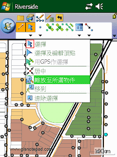
ArcPad 10-Zoom To Selected Feature
Step1 點選[縮放至所選物件]

Step2 原本右下角選取(反藍)的物件,移動到視窗中央並放大

Go To Selected Feature 移至所選物件位置
Activate line-of-sight or ArcLogistics navigation. 設定己選物件為現時導航的目的地

Clear Selected 清除選擇
Feature Unselect the selected feature. 放棄已選物件
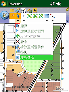
ArcPad 10-Clear Selected
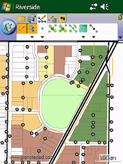
Step1 點選[清除選擇]

Step2 原右下角反藍被選取物件,取消選取


Reference to ESRI® ArcPad® 10 Quick Reference

2012年7月3日

ArcPad.Edit Toolbar 編輯工具列

Start/Stop Editing 啓動/停止編輯
Display a submenu containing all the editable layers in the ArcPad map.Tapping a layer toggles its editing state. 顯示在ArcPad地圖中所有可編輯圖層清單,勾選要編輯的圖層

Select 選擇
Activate the Select tool. 啓動選擇工具

Point 繪畫點
Activate the point feature type for data capture. 啓動畫圖功能

Capture Point Using GPS 使用GPS獲取點
Capture a point feature in the editable point layer using the current GPS position. 在可編輯圖層中使用GPS獲取點

Add GPS Vertex GPS 獲取頂點
Capture a single vertex in the current polyline or polygon feature using the current GPS position. 使用當前GPS位置位為目前的線或多邊形獲取頂點

Add GPS Vertices Continuously 連續使用GPS增加頂點
Continuously capture vertices in the current polyline or polygon feature using the current GPS position. 連續使用GPS增加頂點

Feature Properties 物件屬性
Open the Feature Properties dialog box (or custom edit form) for the selected feature. 開啟所選物件的屬性對話盒或自定的編輯表格
  
Offset Point 偏移
Activate offsets for point data capture. 啟動偏移以獲取點的數據


Reference to ESRI® ArcPad® 10 Quick Reference